


La Source de Gorniés

DiagMan
User
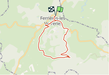

Length
7.6 km

Max alt
323 m

Uphill gradient
139 m
Km-Effort
9.4 km

Min alt
230 m

Downhill gradient
139 m
Boucle
Yes
Creation date :
2023-10-08 09:46:31.178
Updated on :
2023-10-08 09:50:20.084
2h08
Difficulty : Medium

FREE GPS app for hiking
 SityTrail
IGN / Geographical institutes
SityTrail Plus
The world is yours!
About
Trail Walking of 7.6 km to be discovered at Occitania, Hérault, Ferrières-les-Verreries. This trail is proposed by DiagMan.
Description
Au départ de Ferrières les Verreries


Positioning
Country:
France
Region :
Occitania
Department/Province :
Hérault
Municipality :
Ferrières-les-Verreries
Location:
Unknown
Start:(Dec)
Start:(UTM)
564200 ; 4858830 (31T) N.
Comments