


Wikiloc Hornebos (PVDB)

Peter.vdbergh
User GUIDE
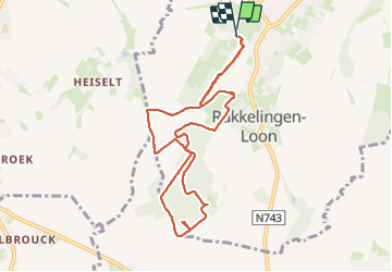

Length
8.6 km

Max alt
128 m

Uphill gradient
91 m
Km-Effort
9.8 km

Min alt
87 m

Downhill gradient
90 m
Boucle
Yes
Creation date :
2023-10-08 12:39:14.601
Updated on :
2023-10-08 16:03:38.842
2h01
Difficulty : Easy

FREE GPS app for hiking
 SityTrail
IGN / Geographical institutes
SityTrail Plus
The world is yours!
About
Trail Walking of 8.6 km to be discovered at Flanders, Limburg, Heers. This trail is proposed by Peter.vdbergh.
Photos
 - Photo 1")
 - Photo 2")
 - Photo 3")
 - Photo 4")
 - Photo 5")
 - Photo 6")
 - Photo 7")
 - Photo 8")
 - Photo 9")
 - Photo 10")
 - Photo 11")
 - Photo 12")
 - Photo 13")
 - Photo 14")
 - Photo 15")
 - Photo 16")
 - Photo 17")
 - Photo 18")
 - Photo 19")
 - Photo 20")
Positioning
Country:
Belgium
Region :
Flanders
Department/Province :
Limburg
Municipality :
Heers
Location:
Mechelen-Bovelingen
Start:(Dec)
Start:(UTM)
658776 ; 5622985 (31U) N.
Comments