


oneux . comblain-la-tour . oneux

stef789
User GUIDE
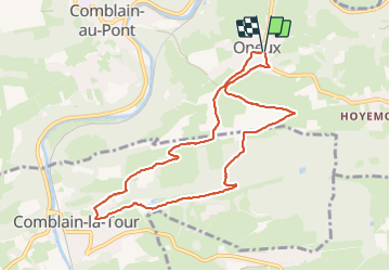

Length
8.4 km

Max alt
289 m

Uphill gradient
222 m
Km-Effort
11.4 km

Min alt
117 m

Downhill gradient
222 m
Boucle
Yes
Creation date :
2023-10-08 13:19:49.964
Updated on :
2023-10-08 16:02:10.866
2h41
Difficulty : Medium

FREE GPS app for hiking
 SityTrail
IGN / Geographical institutes
SityTrail Plus
The world is yours!
About
Trail Walking of 8.4 km to be discovered at Wallonia, Liège, Comblain-au-Pont. This trail is proposed by stef789.
Positioning
Country:
Belgium
Region :
Wallonia
Department/Province :
Liège
Municipality :
Comblain-au-Pont
Location:
Unknown
Start:(Dec)
Start:(UTM)
684486 ; 5594403 (31U) N.
Comments