Trail Walking Angoulême - De saint Cybard à Fléac - Photo

De saint Cybard à Fléac

© OpenStreetMap contributors
Length
Length
11.4 km
Max alt
Max alt
75 m
Uphill gradient
Uphill gradient
156 m
Km-Effort
Km-Effort  
13.5 km
Min alt
Min alt
26 m
Downhill gradient
Downhill gradient
153 m
Boucle
Boucle
No
Creation date :
2015-02-08 00:00:00.0
Updated on :
2015-02-08 00:00:00.0

(0 Reviews)

Walking
Walking
2h55
Difficulty : Unknown

Scan this QR Code to open this trail in the SityTrail application

FREE GPS app for hiking

Logo SityTrail SityTrail

IGN / Geographical institutes

Download SityTrail from the App Store Download SityTrail from Google Play

Logo SityTrail SityTrail Plus

The world is yours!

Download SityTrail from the App Store Download SityTrail from Google Play Download SityTrail on Huawei AppGallery

About

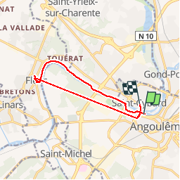
Trail Walking of 11.4 km to be discovered at New Aquitaine, Charente, Angoulême. This trail is proposed by alainjoseph6.

Description

Une ballade au bord de la Charente jusqu'à la Mairie de Fléac, retour en bus jusqu'au jardin vert et descente à pieds place Mulack

Elevation profile

Photos

Points of interest

Point of interest Saint-Yrieix-sur-Charente - l'écluse de Thouérat - Photo
alainjoseph6
SAINT-YRIEIX-SUR-CHARENTE 
Point of interest Saint-Yrieix-sur-Charente - La Charente à Thouérat - Photo
alainjoseph6
SAINT-YRIEIX-SUR-CHARENTE 
Point of interest Fléac - La Charente à Nersac - Photo
alainjoseph6
Point of interest Fléac - Le château de Nersac - Photo
alainjoseph6

Positioning

Country:
France
Region :
New Aquitaine
Department/Province :
Charente
Municipality :
Angoulême
Location:
Unknown
Start:(UTM)
277916 ; 5059553 (31T) N.


Close
My subscriptions