


L'Aiguille n° 1-par Cordéac-massif du Dévoluy

okfred26
User
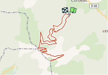

Length
14.1 km

Max alt
2029 m

Uphill gradient
1097 m
Km-Effort
29 km

Min alt
989 m

Downhill gradient
1104 m
Boucle
Yes
Creation date :
2023-10-09 09:53:44.011
Updated on :
2023-10-09 09:56:00.681
6h31
Difficulty : Very difficult

FREE GPS app for hiking
 SityTrail
IGN / Geographical institutes
SityTrail Plus
The world is yours!
About
Trail Walking of 14.1 km to be discovered at Auvergne-Rhône-Alpes, Isère, Châtel-en-Trièves. This trail is proposed by okfred26.
Positioning
Country:
France
Region :
Auvergne-Rhône-Alpes
Department/Province :
Isère
Municipality :
Châtel-en-Trièves
Location:
Cordéac
Start:(Dec)
Start:(UTM)
724119 ; 4966916 (31T) N.
Comments