


Anthisnes - Vien - La Rock - Les Stépennes depuis l'Avouerie

Delhezpy
User
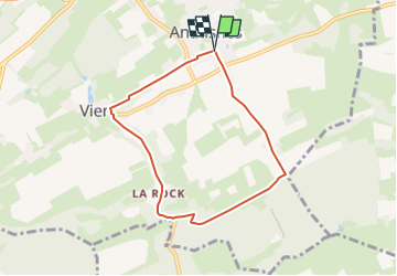

Length
6 km

Max alt
261 m

Uphill gradient
95 m
Km-Effort
7.3 km

Min alt
182 m

Downhill gradient
98 m
Boucle
Yes
Creation date :
2023-10-09 11:07:51.588
Updated on :
2025-01-09 14:18:24.598
1h39
Difficulty : Easy

FREE GPS app for hiking
 SityTrail
IGN / Geographical institutes
SityTrail Plus
The world is yours!
About
Trail On foot of 6 km to be discovered at Wallonia, Liège, Anthisnes. This trail is proposed by Delhezpy.
Positioning
Country:
Belgium
Region :
Wallonia
Department/Province :
Liège
Municipality :
Anthisnes
Location:
Unknown
Start:(Dec)
Start:(UTM)
679061 ; 5595011 (31U) N.
Comments