


Boucle de Gilete à Puget-Theniers

franquen
User
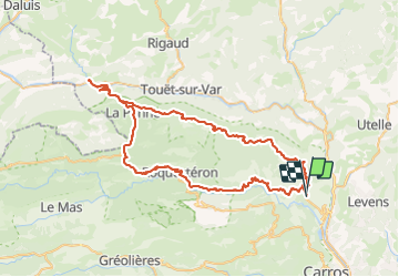

Length
85 km

Max alt
1155 m

Uphill gradient
2006 m
Km-Effort
112 km

Min alt
278 m

Downhill gradient
2038 m
Boucle
No
Creation date :
2023-10-09 09:10:33.984
Updated on :
2023-10-09 15:46:41.599
4h49
Difficulty : Easy

FREE GPS app for hiking
 SityTrail
IGN / Geographical institutes
SityTrail Plus
The world is yours!
About
Trail Electric bike of 85 km to be discovered at Provence-Alpes-Côte d'Azur, Maritime Alps, Gilette. This trail is proposed by franquen.
Description
De beaux paysages, très peu de circulation notamment sur la partie nord. 85km : Attention à la batterie !
Positioning
Country:
France
Region :
Provence-Alpes-Côte d'Azur
Department/Province :
Maritime Alps
Municipality :
Gilette
Location:
Unknown
Start:(Dec)
Start:(UTM)
352382 ; 4857430 (32T) N.
Comments