


Colline Saint Jacques

denel
User
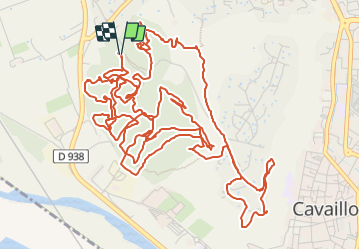

Length
13 km

Max alt
185 m

Uphill gradient
396 m
Km-Effort
18.3 km

Min alt
70 m

Downhill gradient
398 m
Boucle
Yes
Creation date :
2023-10-11 06:36:50.899
Updated on :
2023-10-11 08:52:44.767
2h14
Difficulty : Difficult

FREE GPS app for hiking
 SityTrail
IGN / Geographical institutes
SityTrail Plus
The world is yours!
About
Trail Mountain bike of 13 km to be discovered at Provence-Alpes-Côte d'Azur, Vaucluse, Cavaillon. This trail is proposed by denel.
Description
VTTAE assez technique
Fantastique vue et single dans la Colline saint Jacques au dessus de Cavaillon
Positioning
Country:
France
Region :
Provence-Alpes-Côte d'Azur
Department/Province :
Vaucluse
Municipality :
Cavaillon
Location:
Unknown
Start:(Dec)
Start:(UTM)
662402 ; 4856670 (31T) N.
Comments