


Razigueres -planèzes

robertperello
User
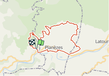

Length
10.5 km

Max alt
316 m

Uphill gradient
290 m
Km-Effort
14.4 km

Min alt
108 m

Downhill gradient
287 m
Boucle
Yes
Creation date :
2023-10-11 07:12:37.0
Updated on :
2023-10-11 12:11:19.417
3h07
Difficulty : Easy

FREE GPS app for hiking
 SityTrail
IGN / Geographical institutes
SityTrail Plus
The world is yours!
About
Trail Walking of 10.5 km to be discovered at Occitania, Pyrénées-Orientales, Rasiguères. This trail is proposed by robertperello.
Description
Pk:mairie
Positioning
Country:
France
Region :
Occitania
Department/Province :
Pyrénées-Orientales
Municipality :
Rasiguères
Location:
Unknown
Start:(Dec)
Start:(UTM)
468100 ; 4734893 (31T) N.
Comments