


greoliered
© OpenStreetMap contributors


5h01
Difficulty : Difficult


Length
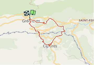
8.6 km
Max alt
849 m
Uphill gradient
494 m
Km-Effort
15.2 km
Min alt
547 m
Downhill gradient
495 m
Boucle
Yes
Creation date :
2023-10-12 07:53:15.689
Updated on :
2023-10-12 12:55:53.447
5h01
Difficulty : Difficult
FREE GPS app for hiking
 SityTrail
IGN / Geographical institutes
SityTrail Plus
The world is yours!
About
Trail Walking of 8.6 km to be discovered at Provence-Alpes-Côte d'Azur, Maritime Alps, Gréolières. This trail is proposed by Denis Danielle Berthier.
Description
rando
Positioning
Country:
France
Region :
Provence-Alpes-Côte d'Azur
Department/Province :
Maritime Alps
Municipality :
Gréolières
Location:
Unknown
Start:(Dec)
Start:(UTM)
334480 ; 4851314 (32T) N.
Comments