


Rustres

alinetpierre
User
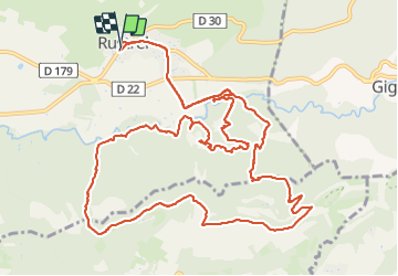

Length
17.5 km

Max alt
574 m

Uphill gradient
429 m
Km-Effort
23 km

Min alt
332 m

Downhill gradient
420 m
Boucle
Yes
Creation date :
2023-10-15 07:18:23.0
Updated on :
2023-10-15 12:49:39.084

FREE GPS app for hiking
 SityTrail
IGN / Geographical institutes
SityTrail Plus
The world is yours!
About
Trail of 17.5 km to be discovered at Provence-Alpes-Côte d'Azur, Vaucluse, Rustrel. This trail is proposed by alinetpierre.
Description
Attention passages sur des chemins privés, certainement à éviter par grande affluence , voir payant dans le Colorado de Rustrel.
Positioning
Country:
France
Region :
Provence-Alpes-Côte d'Azur
Department/Province :
Vaucluse
Municipality :
Rustrel
Location:
Unknown
Start:(Dec)
Start:(UTM)
699407 ; 4866368 (31T) N.
Comments