


Lac_monteynard_210923

d.rognon
User
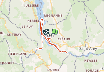

Length
13.2 km

Max alt
504 m

Uphill gradient
114 m
Km-Effort
14.8 km

Min alt
467 m

Downhill gradient
127 m
Boucle
Yes
Creation date :
2023-09-21 07:42:51.36
Updated on :
2023-10-15 14:47:28.988
1h34
Difficulty : Easy

FREE GPS app for hiking
 SityTrail
IGN / Geographical institutes
SityTrail Plus
The world is yours!
About
Trail Motorboat of 13.2 km to be discovered at Auvergne-Rhône-Alpes, Isère, Mayres-Savel. This trail is proposed by d.rognon.
Positioning
Country:
France
Region :
Auvergne-Rhône-Alpes
Department/Province :
Isère
Municipality :
Mayres-Savel
Location:
Unknown
Start:(Dec)
Start:(UTM)
712435 ; 4973251 (31T) N.
Comments