


2023-10-16_08h10m57_SityTrail - Rocher Rond-Aller-Retour-reconnaissance du 12-10-2023 (ibp 124 )

okfred26
User
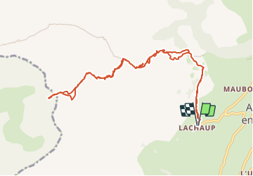

Length
11.5 km

Max alt
2444 m

Uphill gradient
1044 m
Km-Effort
25 km

Min alt
1393 m

Downhill gradient
1042 m
Boucle
Yes
Creation date :
2023-10-16 06:10:57.196
Updated on :
2023-10-16 06:11:00.011

FREE GPS app for hiking
 SityTrail
IGN / Geographical institutes
SityTrail Plus
The world is yours!
About
Trail of 11.5 km to be discovered at Provence-Alpes-Côte d'Azur, Hautes-Alpes, Le Dévoluy. This trail is proposed by okfred26.
Positioning
Country:
France
Region :
Provence-Alpes-Côte d'Azur
Department/Province :
Hautes-Alpes
Municipality :
Le Dévoluy
Location:
Agnières-en-Dévoluy
Start:(Dec)
Start:(UTM)
726908 ; 4952710 (31T) N.
Comments