


St Méry - Blandy les tours - 10 km

jeanmarcMasson
User GUIDE
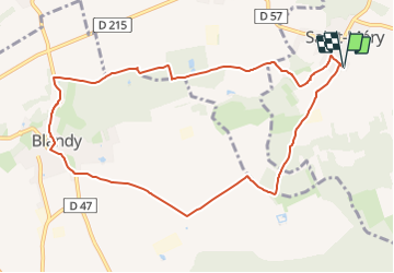

Length
9.8 km

Max alt
101 m

Uphill gradient
92 m
Km-Effort
11.1 km

Min alt
65 m

Downhill gradient
92 m
Boucle
Yes
Creation date :
2023-10-17 16:29:09.446
Updated on :
2023-10-17 16:31:07.662
2h30
Difficulty : Medium

FREE GPS app for hiking
 SityTrail
IGN / Geographical institutes
SityTrail Plus
The world is yours!
About
Trail Walking of 9.8 km to be discovered at Ile-de-France, Seine-et-Marne, Saint-Méry. This trail is proposed by jeanmarcMasson.
Positioning
Country:
France
Region :
Ile-de-France
Department/Province :
Seine-et-Marne
Municipality :
Saint-Méry
Location:
Unknown
Start:(Dec)
Start:(UTM)
487281 ; 5380222 (31U) N.
Comments