


Communards

tine60
User

Length
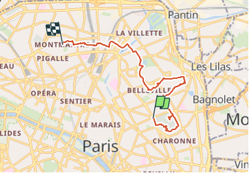
13.1 km

Max alt
132 m

Uphill gradient
236 m
Km-Effort
16 km

Min alt
44 m

Downhill gradient
171 m
Boucle
No
Creation date :
2023-10-20 07:35:59.0
Updated on :
2023-10-20 13:53:39.664

FREE GPS app for hiking
 SityTrail
IGN / Geographical institutes
SityTrail Plus
The world is yours!
About
Trail of 13.1 km to be discovered at Ile-de-France, Paris, Paris. This trail is proposed by tine60.
Positioning
Country:
France
Region :
Ile-de-France
Department/Province :
Paris
Municipality :
Paris
Location:
11th Arrondissement
Start:(Dec)
Start:(UTM)
455066 ; 5412367 (31U) N.
Comments