


depuis le pont des Amayeres

CABERMAT
User
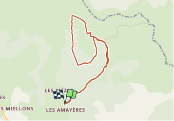

Length
9.5 km

Max alt
1638 m

Uphill gradient
500 m
Km-Effort
16.2 km

Min alt
1168 m

Downhill gradient
501 m
Boucle
Yes
Creation date :
2023-10-16 09:44:40.984
Updated on :
2023-10-20 16:30:11.272
3h23
Difficulty : Difficult

FREE GPS app for hiking
 SityTrail
IGN / Geographical institutes
SityTrail Plus
The world is yours!
About
Trail Walking of 9.5 km to be discovered at Auvergne-Rhône-Alpes, Drôme, Lus-la-Croix-Haute. This trail is proposed by CABERMAT.
Description
col de torchelon et tour du...
Positioning
Country:
France
Region :
Auvergne-Rhône-Alpes
Department/Province :
Drôme
Municipality :
Lus-la-Croix-Haute
Location:
Unknown
Start:(Dec)
Start:(UTM)
714745 ; 4952157 (31T) N.
Comments