


21 octobre 2023 bessenais

Parodie69
User
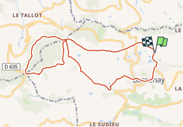

Length
10.5 km

Max alt
645 m

Uphill gradient
329 m
Km-Effort
14.9 km

Min alt
368 m

Downhill gradient
324 m
Boucle
Yes
Creation date :
2023-10-21 13:41:46.518
Updated on :
2023-10-21 16:00:53.946
2h18
Difficulty : Difficult

FREE GPS app for hiking
 SityTrail
IGN / Geographical institutes
SityTrail Plus
The world is yours!
About
Trail Walking of 10.5 km to be discovered at Auvergne-Rhône-Alpes, Rhône, Bessenay. This trail is proposed by Parodie69.
Positioning
Country:
France
Region :
Auvergne-Rhône-Alpes
Department/Province :
Rhône
Municipality :
Bessenay
Location:
Unknown
Start:(Dec)
Start:(UTM)
620910 ; 5071070 (31T) N.
Comments