


Privas

raygautier
User
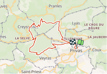

Length
20 km

Max alt
626 m

Uphill gradient
863 m
Km-Effort
32 km

Min alt
262 m

Downhill gradient
862 m
Boucle
Yes
Creation date :
2023-10-22 06:32:34.0
Updated on :
2023-10-22 14:03:32.254

FREE GPS app for hiking
 SityTrail
IGN / Geographical institutes
SityTrail Plus
The world is yours!
About
Trail of 20 km to be discovered at Auvergne-Rhône-Alpes, Ardèche, Privas. This trail is proposed by raygautier.
Positioning
Country:
France
Region :
Auvergne-Rhône-Alpes
Department/Province :
Ardèche
Municipality :
Privas
Location:
Unknown
Start:(Dec)
Start:(UTM)
626627 ; 4954921 (31T) N.
Comments