


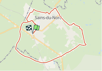
Sains du Nord

mjh
User

Length
11.3 km

Max alt
227 m

Uphill gradient
111 m
Km-Effort
12.8 km

Min alt
167 m

Downhill gradient
111 m
Boucle
Yes
Creation date :
2023-10-22 11:27:23.67
Updated on :
2023-10-22 14:18:08.613
2h43
Difficulty : Easy
2h44
Difficulty : Easy

FREE GPS app for hiking
 SityTrail
IGN / Geographical institutes
SityTrail Plus
The world is yours!
About
Trail Walking of 11.3 km to be discovered at Hauts-de-France, Nord, Sains-du-Nord. This trail is proposed by mjh.
Photos

Positioning
Country:
France
Region :
Hauts-de-France
Department/Province :
Nord
Municipality :
Sains-du-Nord
Location:
Unknown
Start:(Dec)
Start:(UTM)
571665 ; 5548998 (31U) N.
Comments