


22/10/23 - Bernardwiller

delm
User
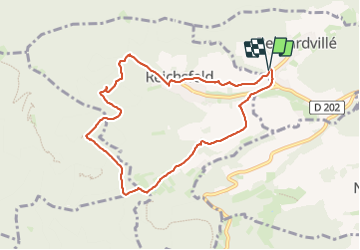

Length
8.2 km

Max alt
600 m

Uphill gradient
324 m
Km-Effort
12.5 km

Min alt
280 m

Downhill gradient
319 m
Boucle
Yes
Creation date :
2023-10-22 12:37:32.0
Updated on :
2023-10-22 15:15:44.256
2h24
Difficulty : Easy

FREE GPS app for hiking
 SityTrail
IGN / Geographical institutes
SityTrail Plus
The world is yours!
About
Trail Walking of 8.2 km to be discovered at Grand Est, Bas-Rhin, Bernardvillé. This trail is proposed by delm.
Description
Très belle et agréable randonnée
Positioning
Country:
France
Region :
Grand Est
Department/Province :
Bas-Rhin
Municipality :
Bernardvillé
Location:
Unknown
Start:(Dec)
Start:(UTM)
381445 ; 5358517 (32U) N.
Comments