


Trail du Bouquetin

SERGIO110_1
User
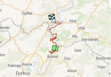

Length
18.8 km

Max alt
221 m

Uphill gradient
586 m
Km-Effort
27 km

Min alt
113 m

Downhill gradient
614 m
Boucle
No
Creation date :
2015-02-10 00:00:00.0
Updated on :
2015-02-10 00:00:00.0
--
Difficulty : Difficult

FREE GPS app for hiking
 SityTrail
IGN / Geographical institutes
SityTrail Plus
The world is yours!
About
Trail Running of 18.8 km to be discovered at Wallonia, Luxembourg, Durbuy. This trail is proposed by SERGIO110_1.
Positioning
Country:
Belgium
Region :
Wallonia
Department/Province :
Luxembourg
Municipality :
Durbuy
Location:
Bomal
Start:(Dec)
Start:(UTM)
679142 ; 5583711 (31U) N.
Comments