


carpiagne a st Marthe. l'estret

tessonnierg
User
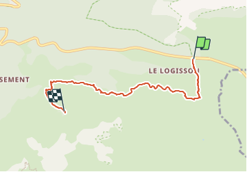

Length
5.8 km

Max alt
384 m

Uphill gradient
214 m
Km-Effort
8.4 km

Min alt
186 m

Downhill gradient
138 m
Boucle
No
Creation date :
2023-10-10 08:21:51.85
Updated on :
2023-10-24 19:52:54.567
2h18
Difficulty : Medium

FREE GPS app for hiking
 SityTrail
IGN / Geographical institutes
SityTrail Plus
The world is yours!
About
Trail Walking of 5.8 km to be discovered at Provence-Alpes-Côte d'Azur, Bouches-du-Rhône, Marseille. This trail is proposed by tessonnierg.
Description
2 étoiles
Positioning
Country:
France
Region :
Provence-Alpes-Côte d'Azur
Department/Province :
Bouches-du-Rhône
Municipality :
Marseille
Location:
9th Arrondissement
Start:(Dec)
Start:(UTM)
702988 ; 4790171 (31T) N.
Comments