


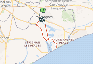
portiragnes étang de l estagnol

Daron34
User

Length
8.7 km

Max alt
9 m

Uphill gradient
30 m
Km-Effort
9.1 km

Min alt
-2 m

Downhill gradient
29 m
Boucle
No
Creation date :
2023-10-27 11:56:42.616
Updated on :
2023-10-27 15:07:23.806
2h41
Difficulty : Very easy

FREE GPS app for hiking
 SityTrail
IGN / Geographical institutes
SityTrail Plus
The world is yours!
About
Trail Walking of 8.7 km to be discovered at Occitania, Hérault, Portiragnes. This trail is proposed by Daron34.
Description
Boucle au départ de l écluse de Portiragnes d environ 9kms avec traversée de l étang de l estagnol pour découvrir faune et flore de la Maïre
Positioning
Country:
France
Region :
Occitania
Department/Province :
Hérault
Municipality :
Portiragnes
Location:
Unknown
Start:(Dec)
Start:(UTM)
526710 ; 4794689 (31T) N.
Comments