2015-02-11 Rando Etréchy

jchezlemas
User
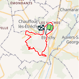

Length
12.4 km

Max alt
155 m

Uphill gradient
260 m
Km-Effort
15.9 km

Min alt
68 m

Downhill gradient
264 m
Boucle
Yes
Creation date :
2015-02-11 00:00:00.0
Updated on :
2015-02-11 00:00:00.0
3h25
Difficulty : Easy

FREE GPS app for hiking
 SityTrail
IGN / Geographical institutes
SityTrail Plus
The world is yours!
About
Trail Walking of 12.4 km to be discovered at Ile-de-France, Essonne, Étréchy. This trail is proposed by jchezlemas.
Positioning
Country:
France
Region :
Ile-de-France
Department/Province :
Essonne
Municipality :
Étréchy
Location:
Unknown
Start:(Dec)
Start:(UTM)
440008 ; 5371663 (31U) N.
Comments