


Carrières de la Rochepot

GUERLACH
User
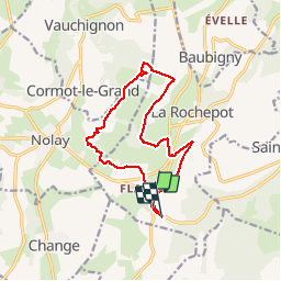

Length
13.8 km

Max alt
553 m

Uphill gradient
324 m
Km-Effort
18.2 km

Min alt
366 m

Downhill gradient
334 m
Boucle
No
Creation date :
2015-02-11 00:00:00.0
Updated on :
2015-02-11 00:00:00.0
3h14
Difficulty : Medium

FREE GPS app for hiking
 SityTrail
IGN / Geographical institutes
SityTrail Plus
The world is yours!
About
Trail Walking of 13.8 km to be discovered at Bourgogne-Franche-Comté, Côte-d'Or, La Rochepot. This trail is proposed by GUERLACH.
Description
A travers les vignes
Positioning
Country:
France
Region :
Bourgogne-Franche-Comté
Department/Province :
Côte-d'Or
Municipality :
La Rochepot
Location:
Unknown
Start:(Dec)
Start:(UTM)
626785 ; 5199564 (31T) N.
Comments