


paullile - Cap bear via la mer retour via les vignes

stef789
User GUIDE
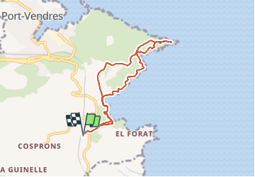

Length
8 km

Max alt
87 m

Uphill gradient
213 m
Km-Effort
10.9 km

Min alt
0 m

Downhill gradient
213 m
Boucle
Yes
Creation date :
2023-10-28 10:12:53.886
Updated on :
2023-10-28 15:01:55.586
4h48
Difficulty : Medium

FREE GPS app for hiking
 SityTrail
IGN / Geographical institutes
SityTrail Plus
The world is yours!
About
Trail Walking of 8 km to be discovered at Occitania, Pyrénées-Orientales, Port-Vendres. This trail is proposed by stef789.
Photos


21 photos in total. Please click on a photo to see them all in the gallery.
Positioning
Country:
France
Region :
Occitania
Department/Province :
Pyrénées-Orientales
Municipality :
Port-Vendres
Location:
Unknown
Start:(Dec)
Start:(UTM)
509704 ; 4705177 (31T) N.
Comments