


rando Dohan Guy

Tommy Eric
User
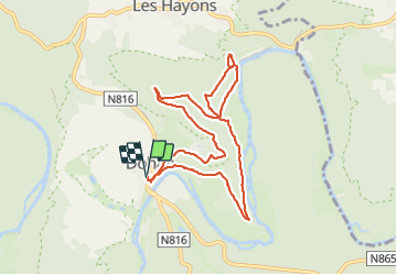

Length
8.4 km

Max alt
358 m

Uphill gradient
300 m
Km-Effort
12.4 km

Min alt
237 m

Downhill gradient
300 m
Boucle
Yes
Creation date :
2023-10-28 11:31:54.679
Updated on :
2023-10-28 15:09:07.361
3h36
Difficulty : Difficult

FREE GPS app for hiking
 SityTrail
IGN / Geographical institutes
SityTrail Plus
The world is yours!
About
Trail Walking of 8.4 km to be discovered at Wallonia, Luxembourg, Bouillon. This trail is proposed by Tommy Eric.
Positioning
Country:
Belgium
Region :
Wallonia
Department/Province :
Luxembourg
Municipality :
Bouillon
Location:
Unknown
Start:(Dec)
Start:(UTM)
654121 ; 5518155 (31U) N.
Comments