


Tête des Chaudière via Roche du Coin/pas de la Balme

okfred26
User
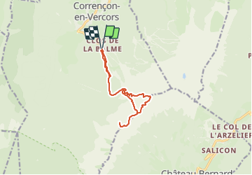

Length
11.5 km

Max alt
2055 m

Uphill gradient
1020 m
Km-Effort
25 km

Min alt
1236 m

Downhill gradient
1019 m
Boucle
Yes
Creation date :
2023-10-28 17:48:45.424
Updated on :
2023-10-28 17:51:10.172
5h42
Difficulty : Very difficult

FREE GPS app for hiking
 SityTrail
IGN / Geographical institutes
SityTrail Plus
The world is yours!
About
Trail Walking of 11.5 km to be discovered at Auvergne-Rhône-Alpes, Isère, Corrençon-en-Vercors. This trail is proposed by okfred26.
Positioning
Country:
France
Region :
Auvergne-Rhône-Alpes
Department/Province :
Isère
Municipality :
Corrençon-en-Vercors
Location:
Unknown
Start:(Dec)
Start:(UTM)
699356 ; 4988184 (31T) N.
Comments