


cessens col du Sapenay

Jean-Marc C
User
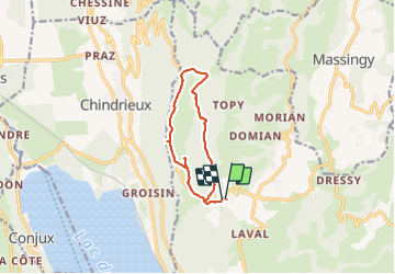

Length
10.3 km

Max alt
969 m

Uphill gradient
374 m
Km-Effort
15.3 km

Min alt
711 m

Downhill gradient
369 m
Boucle
Yes
Creation date :
2023-10-29 13:06:35.273
Updated on :
2023-10-29 16:36:57.024
3h29
Difficulty : Difficult

FREE GPS app for hiking
 SityTrail
IGN / Geographical institutes
SityTrail Plus
The world is yours!
About
Trail Walking of 10.3 km to be discovered at Auvergne-Rhône-Alpes, Savoy, Entrelacs. This trail is proposed by Jean-Marc C.
Positioning
Country:
France
Region :
Auvergne-Rhône-Alpes
Department/Province :
Savoy
Municipality :
Entrelacs
Location:
Unknown
Start:(Dec)
Start:(UTM)
723990 ; 5075724 (31T) N.
Comments