


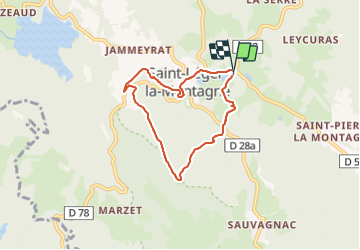
Saint Leger la Montagne - pierre tremblante

rbruant
User

Length
6 km

Max alt
625 m

Uphill gradient
172 m
Km-Effort
8.4 km

Min alt
502 m

Downhill gradient
177 m
Boucle
Yes
Creation date :
2023-11-01 14:45:51.419
Updated on :
2023-11-01 16:45:10.273
1h58
Difficulty : Easy

FREE GPS app for hiking
 SityTrail
IGN / Geographical institutes
SityTrail Plus
The world is yours!
About
Trail Walking of 6 km to be discovered at New Aquitaine, Haute-Vienne, Saint-Léger-la-Montagne. This trail is proposed by rbruant.
Photos

Positioning
Country:
France
Region :
New Aquitaine
Department/Province :
Haute-Vienne
Municipality :
Saint-Léger-la-Montagne
Location:
Unknown
Start:(Dec)
Start:(UTM)
378239 ; 5098585 (31T) N.
Comments