Trail Walking Leyr - Leyr 16 190m +446m - Photo
© OpenStreetMap contributors
Length
Length
16.2 km
Max alt
Max alt
414 m
Uphill gradient
Uphill gradient
446 m
Km-Effort
Km-Effort  
22 km
Min alt
Min alt
230 m
Downhill gradient
Downhill gradient
445 m
Boucle
Boucle
Yes
Creation date :
2023-11-03 07:59:35.135
Updated on :
2024-01-09 19:44:39.653

(0 Reviews)

Walking
Walking
5h01
Difficulty : Very difficult

Scan this QR Code to open this trail in the SityTrail application

FREE GPS app for hiking

Logo SityTrail SityTrail

IGN / Geographical institutes

Download SityTrail from the App Store Download SityTrail from Google Play

Logo SityTrail SityTrail World

The world is yours!

Download SityTrail from the App Store Download SityTrail from Google Play Download SityTrail on Huawei AppGallery

About

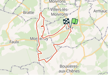
Trail Walking of 16.2 km to be discovered at Grand Est, Meurthe-et-Moselle, Leyr. This trail is proposed by DanielROLLET.

Description

2023 11 03 - 9:00 à 13:00 - Avec Marie
Départ/Retour église de Leyr.
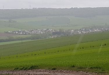
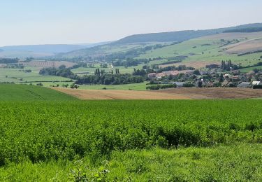
Temps frais couvert puis ensoleillé
Quelques beaux panoramas.

Elevation profile

Positioning

Country:
France
Region :
Grand Est
Department/Province :
Meurthe-et-Moselle
Municipality :
Leyr
Location:
Unknown
Start:(UTM)
299177 ; 5409089 (32U) N.

Trails nearby

Trail Walking Leyr - LEYR - LE PLATEAU DE LA ROCHETTE - Photo
Walking
jean-marie.parachini

Walking

Easy
Leyr, Grand Est, Meurthe-et-Moselle, France
12.1 km | 15.5 km-effort
5h 59min
Yes
Trail Walking Montenoy - MONTENOY - LE COL DE VASSUCHAMP - Photo
Walking
jean-marie.parachini

Walking

Easy
Montenoy, Grand Est, Meurthe-et-Moselle, France
12.4 km | 16.4 km-effort
4h 33min
Yes
Trail Walking Bouxières-aux-Chênes - tour crany 29/5/2019 - Photo
Walking
Morel54

Walking

Very easy
(1)
Bouxières-aux-Chênes, Grand Est, Meurthe-et-Moselle, France
11.1 km | 14 km-effort
3h 42min
Yes
Trail On foot Faulx - Circuit L : Variant Faulx - Photo
On foot
PRO

On foot

Easy
Faulx, Grand Est, Meurthe-et-Moselle, France
6.3 km | 6.9 km-effort
1h 34min
No
Trail Walking Leyr - Leyr Villers les Moivrons - Photo
Walking
jean-marie.parachini

Walking

Medium
Leyr, Grand Est, Meurthe-et-Moselle, France
32 km | 42 km-effort
6h 38min
No
Trail Walking Leyr - Leyr - plateau de la Rochette - Photo
Walking
jean-marie.parachini

Walking

Easy
Leyr, Grand Est, Meurthe-et-Moselle, France
11.8 km | 15.1 km-effort
6h 4min
Yes
Trail Walking Leyr - Leyr 15 000m +432m - Photo
Walking
DanielROLLET

Walking

Very difficult
Leyr, Grand Est, Meurthe-et-Moselle, France
15 km | 21 km-effort
4h 42min
Yes
Trail Nordic walking Eulmont - Eulmont 9 400m +158m - Photo
Nordic walking
DanielROLLET

Nordic walking

Easy
Eulmont, Grand Est, Meurthe-et-Moselle, France
9.4 km | 11.5 km-effort
2h 5min
Yes
Trail Nordic walking Bouxières-aux-Chênes - Bouxières-aux-Chênes (nivelles) 9 200m +206m - Photo
Nordic walking
DanielROLLET

Nordic walking

Very easy
Bouxières-aux-Chênes, Grand Est, Meurthe-et-Moselle, France
9.2 km | 11.9 km-effort
2h 10min
Yes


Close
My subscriptions