


Mon footing, c'est le pied !

adye
User
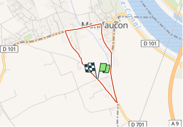

Length
2.9 km

Max alt
32 m

Uphill gradient
17 m
Km-Effort
3.1 km

Min alt
25 m

Downhill gradient
18 m
Boucle
Yes
Creation date :
2023-11-05 10:15:57.732
Updated on :
2023-11-05 10:15:59.715
25m
Difficulty : Very easy

FREE GPS app for hiking
 SityTrail
IGN / Geographical institutes
SityTrail Plus
The world is yours!
About
Trail Running of 2.9 km to be discovered at Occitania, Gard, Saint-Geniès-de-Comolas. This trail is proposed by adye.
Description
C'est pas compliqué tu vois 😘
Positioning
Country:
France
Region :
Occitania
Department/Province :
Gard
Municipality :
Saint-Geniès-de-Comolas
Location:
Unknown
Start:(Dec)
Start:(UTM)
640389 ; 4880849 (31T) N.
Comments