


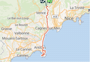
St Jeannet - cap d'Antibes

franquen
User

Length
58 km

Max alt
417 m

Uphill gradient
760 m
Km-Effort
68 km

Min alt
0 m

Downhill gradient
760 m
Boucle
Yes
Creation date :
2023-11-05 09:52:19.225
Updated on :
2023-11-06 18:03:32.848
3h26
Difficulty : Easy

FREE GPS app for hiking
 SityTrail
IGN / Geographical institutes
SityTrail Plus
The world is yours!
About
Trail Mountain bike of 58 km to be discovered at Provence-Alpes-Côte d'Azur, Maritime Alps, Saint-Jeannet. This trail is proposed by franquen.
Positioning
Country:
France
Region :
Provence-Alpes-Côte d'Azur
Department/Province :
Maritime Alps
Municipality :
Saint-Jeannet
Location:
Unknown
Start:(Dec)
Start:(UTM)
350621 ; 4845725 (32T) N.
Comments