


cap blanc nez- 2

doudet
User
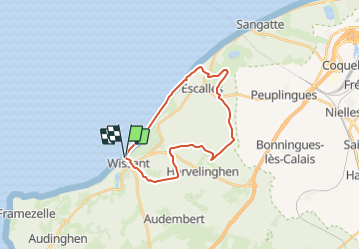

Length
20 km

Max alt
149 m

Uphill gradient
382 m
Km-Effort
25 km

Min alt
0 m

Downhill gradient
380 m
Boucle
Yes
Creation date :
2018-09-11 09:12:29.063
Updated on :
2018-09-11 09:12:29.063
5h30
Difficulty : Unknown

FREE GPS app for hiking
 SityTrail
IGN / Geographical institutes
SityTrail Plus
The world is yours!
About
Trail Other activity of 20 km to be discovered at Hauts-de-France, Pas-de-Calais, Wissant. This trail is proposed by doudet.
Positioning
Country:
France
Region :
Hauts-de-France
Department/Province :
Pas-de-Calais
Municipality :
Wissant
Location:
Unknown
Start:(Dec)
Start:(UTM)
405793 ; 5638223 (31U) N.
Comments