


château de la Napoule

winkelmuller
User
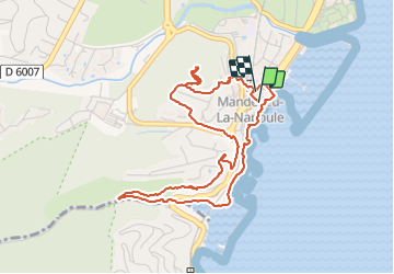

Length
5.5 km

Max alt
117 m

Uphill gradient
158 m
Km-Effort
7.6 km

Min alt
0 m

Downhill gradient
158 m
Boucle
Yes
Creation date :
2015-02-13 00:00:00.0
Updated on :
2015-02-13 00:00:00.0
1h47
Difficulty : Unknown

FREE GPS app for hiking
 SityTrail
IGN / Geographical institutes
SityTrail Plus
The world is yours!
About
Trail Other activity of 5.5 km to be discovered at Provence-Alpes-Côte d'Azur, Maritime Alps, Mandelieu-la-Napoule. This trail is proposed by winkelmuller.
Photos


Positioning
Country:
France
Region :
Provence-Alpes-Côte d'Azur
Department/Province :
Maritime Alps
Municipality :
Mandelieu-la-Napoule
Location:
Unknown
Start:(Dec)
Start:(UTM)
333697 ; 4820976 (32T) N.
Comments