


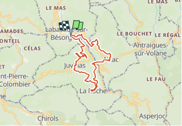
Juvinas Aizac Labastide 14km

thonyc
User GUIDE

Length
14.4 km

Max alt
773 m

Uphill gradient
583 m
Km-Effort
22 km

Min alt
498 m

Downhill gradient
584 m
Boucle
Yes
Creation date :
2023-11-08 10:55:19.012
Updated on :
2023-11-18 22:09:18.344
4h40
Difficulty : Medium

FREE GPS app for hiking
 SityTrail
IGN / Geographical institutes
SityTrail Plus
The world is yours!
About
Trail Walking of 14.4 km to be discovered at Auvergne-Rhône-Alpes, Ardèche, Labastide-sur-Bésorgues. This trail is proposed by thonyc.
Positioning
Country:
France
Region :
Auvergne-Rhône-Alpes
Department/Province :
Ardèche
Municipality :
Labastide-sur-Bésorgues
Location:
Unknown
Start:(Dec)
Start:(UTM)
603201 ; 4953207 (31T) N.
Comments