


maido roche plate

jacquesduchesne
User
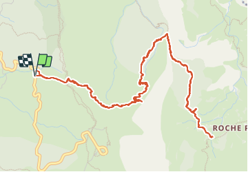

Length
11.7 km

Max alt
2037 m

Uphill gradient
1182 m
Km-Effort
27 km

Min alt
1075 m

Downhill gradient
1175 m
Boucle
Yes
Creation date :
2023-11-09 04:48:21.823
Updated on :
2023-11-09 12:31:08.63
7h42
Difficulty : Very difficult

FREE GPS app for hiking
 SityTrail
IGN / Geographical institutes
SityTrail Plus
The world is yours!
About
Trail Walking of 11.7 km to be discovered at Réunion, Unknown, Saint-Paul. This trail is proposed by jacquesduchesne.
Positioning
Country:
France
Region :
Réunion
Department/Province :
Unknown
Municipality :
Saint-Paul
Location:
Unknown
Start:(Dec)
Start:(UTM)
331550 ; 7670036 (40K) S.
Comments