


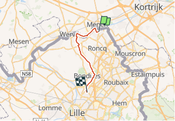
GIVP 1ère Etape Mairie Halluin à Mairie Marcq en Baroeul

dehemjacques
User

Length
21 km

Max alt
50 m

Uphill gradient
141 m
Km-Effort
23 km

Min alt
3 m

Downhill gradient
141 m
Boucle
No
Creation date :
2023-11-09 12:52:34.557
Updated on :
2023-11-09 12:52:39.707
5h10
Difficulty : Very difficult

FREE GPS app for hiking
 SityTrail
IGN / Geographical institutes
SityTrail Plus
The world is yours!
About
Trail Walking of 21 km to be discovered at Hauts-de-France, Nord, Halluin. This trail is proposed by dehemjacques.
Positioning
Country:
France
Region :
Hauts-de-France
Department/Province :
Nord
Municipality :
Halluin
Location:
Unknown
Start:(Dec)
Start:(UTM)
508788 ; 5625644 (31U) N.
Comments