


feins repérage rigole

coglais
User
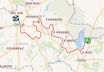

Length
14.4 km

Max alt
88 m

Uphill gradient
105 m
Km-Effort
15.7 km

Min alt
61 m

Downhill gradient
92 m
Boucle
No
Creation date :
2023-11-10 08:11:28.164
Updated on :
2023-11-10 11:29:03.851
2h50
Difficulty : Very easy

FREE GPS app for hiking
 SityTrail
IGN / Geographical institutes
SityTrail Plus
The world is yours!
About
Trail Nordic walking of 14.4 km to be discovered at Brittany, Ille-et-Vilaine, Feins. This trail is proposed by coglais.
Positioning
Country:
France
Region :
Brittany
Department/Province :
Ille-et-Vilaine
Municipality :
Feins
Location:
Unknown
Start:(Dec)
Start:(UTM)
600878 ; 5354914 (30U) N.
Comments