


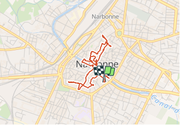
Balade urbaine de Narbonne

Daron34
User


2h16
Difficulty : Easy

FREE GPS app for hiking
 SityTrail
IGN / Geographical institutes
SityTrail Plus
The world is yours!
About
Trail Walking of 4.5 km to be discovered at Occitania, Aude, Narbonne. This trail is proposed by Daron34.
Description
pour vous garer à les stationner sur le parking gratuit Victor Hugo à Narbonne puis vous rendre à pied au départ qui se trouve en face des Halles .Bonne balade
Photos


27 photos in total. Please click on a photo to see them all in the gallery.
Positioning
Comments