


Boffres

raygautier
User
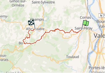

Length
23 km

Max alt
675 m

Uphill gradient
834 m
Km-Effort
32 km

Min alt
161 m

Downhill gradient
448 m
Boucle
No
Creation date :
2023-11-11 09:00:54.0
Updated on :
2023-11-11 15:41:11.429

FREE GPS app for hiking
 SityTrail
IGN / Geographical institutes
SityTrail Plus
The world is yours!
About
Trail of 23 km to be discovered at Auvergne-Rhône-Alpes, Ardèche, Saint-Péray. This trail is proposed by raygautier.
Positioning
Country:
France
Region :
Auvergne-Rhône-Alpes
Department/Province :
Ardèche
Municipality :
Saint-Péray
Location:
Unknown
Start:(Dec)
Start:(UTM)
645099 ; 4978286 (31T) N.
Comments