


Viglain

lemuid
User
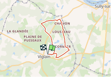

Length
10.7 km

Max alt
153 m

Uphill gradient
92 m
Km-Effort
12 km

Min alt
116 m

Downhill gradient
93 m
Boucle
Yes
Creation date :
2023-11-12 08:02:49.606
Updated on :
2023-11-12 10:33:18.822
2h20
Difficulty : Very easy

FREE GPS app for hiking
 SityTrail
IGN / Geographical institutes
SityTrail Plus
The world is yours!
About
Trail Walking of 10.7 km to be discovered at Centre-Loire Valley, Loiret, Viglain. This trail is proposed by lemuid.
Positioning
Country:
France
Region :
Centre-Loire Valley
Department/Province :
Loiret
Municipality :
Viglain
Location:
Unknown
Start:(Dec)
Start:(UTM)
448062 ; 5286385 (31T) N.
Comments