


ps la gardiette, Bagnols-en-forêt

psester
User
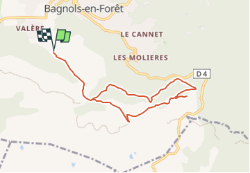

Length
8.6 km

Max alt
355 m

Uphill gradient
302 m
Km-Effort
12.6 km

Min alt
206 m

Downhill gradient
303 m
Boucle
Yes
Creation date :
2023-11-13 08:05:04.236
Updated on :
2024-04-08 17:05:44.279
2h44
Difficulty : Medium

FREE GPS app for hiking
 SityTrail
IGN / Geographical institutes
SityTrail Plus
The world is yours!
About
Trail Walking of 8.6 km to be discovered at Provence-Alpes-Côte d'Azur, Var, Bagnols-en-Forêt. This trail is proposed by psester.
Description
beau point de vue, malheureusement parfois sur la déchetterie de Bagnols
Positioning
Country:
France
Region :
Provence-Alpes-Côte d'Azur
Department/Province :
Var
Municipality :
Bagnols-en-Forêt
Location:
Unknown
Start:(Dec)
Start:(UTM)
313406 ; 4822234 (32T) N.
Comments