


Les petites maures/les 4 vents/les avelans

Michel DUBOIS
User

Length
10.1 km

Max alt
247 m

Uphill gradient
391 m
Km-Effort
15.3 km

Min alt
12 m

Downhill gradient
391 m
Boucle
Yes
Creation date :
2023-11-13 16:35:30.659
Updated on :
2023-11-13 16:38:58.058
3h28
Difficulty : Medium

FREE GPS app for hiking
 SityTrail
IGN / Geographical institutes
SityTrail Plus
The world is yours!
About
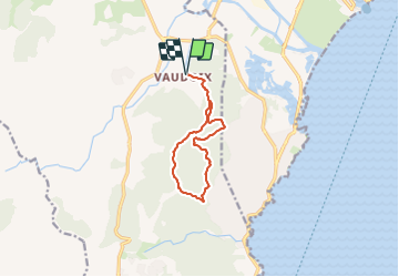
Trail Walking of 10.1 km to be discovered at Provence-Alpes-Côte d'Azur, Var, Roquebrune-sur-Argens. This trail is proposed by Michel DUBOIS.
Description
le Vaudoix raccourci à 10kms en matinée
Positioning
Country:
France
Region :
Provence-Alpes-Côte d'Azur
Department/Province :
Var
Municipality :
Roquebrune-sur-Argens
Location:
Unknown
Start:(Dec)
Start:(UTM)
313327 ; 4808326 (32T) N.
Comments