


Boucle Mgn de Montmaur vers M.F.de Rabiou

rigol05
User
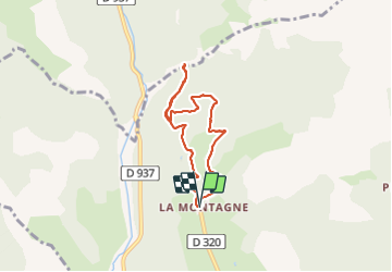

Length
6.3 km

Max alt
1327 m

Uphill gradient
212 m
Km-Effort
9.1 km

Min alt
1160 m

Downhill gradient
209 m
Boucle
Yes
Creation date :
2023-11-14 13:00:44.353
Updated on :
2023-11-14 16:50:29.59
2h04
Difficulty : Medium

FREE GPS app for hiking
 SityTrail
IGN / Geographical institutes
SityTrail Plus
The world is yours!
About
Trail Walking of 6.3 km to be discovered at Provence-Alpes-Côte d'Azur, Hautes-Alpes, Montmaur. This trail is proposed by rigol05.
Description
Sortie du 14-11-2023
De la Montagne jusqu'à Brunsel, la piste est très dégradée et boueuse suite à l'exploitation forestière. Le reste de l'itinéraire est bon.
Positioning
Country:
France
Region :
Provence-Alpes-Côte d'Azur
Department/Province :
Hautes-Alpes
Municipality :
Montmaur
Location:
Unknown
Start:(Dec)
Start:(UTM)
727570 ; 4942310 (31T) N.
Comments