


2023-11-15_23h32m32_trac sentier des vignes

Linerou
User

Length
6.4 km

Max alt
245 m

Uphill gradient
159 m
Km-Effort
8.5 km

Min alt
153 m

Downhill gradient
159 m
Boucle
Yes
Creation date :
2023-11-15 22:32:32.416
Updated on :
2023-12-31 10:13:11.109
1h56
Difficulty : Easy

FREE GPS app for hiking
 SityTrail
IGN / Geographical institutes
SityTrail Plus
The world is yours!
About
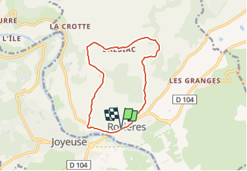
Trail Walking of 6.4 km to be discovered at Auvergne-Rhône-Alpes, Ardèche, Rosières. This trail is proposed by Linerou.
Positioning
Country:
France
Region :
Auvergne-Rhône-Alpes
Department/Province :
Ardèche
Municipality :
Rosières
Location:
Unknown
Start:(Dec)
Start:(UTM)
599764 ; 4926201 (31T) N.
Comments