


Planzolles 16 Nov. 2023

Linerou
User
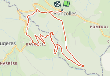

Length
7.1 km

Max alt
514 m

Uphill gradient
218 m
Km-Effort
10 km

Min alt
325 m

Downhill gradient
221 m
Boucle
Yes
Creation date :
2023-11-16 08:33:18.43
Updated on :
2023-11-16 11:43:32.424
2h58
Difficulty : Medium

FREE GPS app for hiking
 SityTrail
IGN / Geographical institutes
SityTrail Plus
The world is yours!
About
Trail Walking of 7.1 km to be discovered at Auvergne-Rhône-Alpes, Ardèche, Planzolles. This trail is proposed by Linerou.
Positioning
Country:
France
Region :
Auvergne-Rhône-Alpes
Department/Province :
Ardèche
Municipality :
Planzolles
Location:
Unknown
Start:(Dec)
Start:(UTM)
591720 ; 4926525 (31T) N.
Comments