Trail Walking Sillans - SityTrail - RD-Sillans-de Recandoux à la Ravageuse - Photo

SityTrail - RD-Sillans-de Recandoux à la Ravageuse

© OpenStreetMap contributors
Length
Length
8.1 km
Max alt
Max alt
429 m
Uphill gradient
Uphill gradient
43 m
Km-Effort
Km-Effort  
8.7 km
Min alt
Min alt
403 m
Downhill gradient
Downhill gradient
47 m
Boucle
Boucle
Yes
Creation date :
2023-11-16 14:55:38.538
Updated on :
2023-11-16 15:24:38.047

(1 Reviews)

Walking
Walking
1h59
Difficulty : Medium

Scan this QR Code to open this trail in the SityTrail application

FREE GPS app for hiking

Logo SityTrail SityTrail

IGN / Geographical institutes

Download SityTrail from the App Store Download SityTrail from Google Play

Logo SityTrail SityTrail World

The world is yours!

Download SityTrail from the App Store Download SityTrail from Google Play Download SityTrail on Huawei AppGallery

About

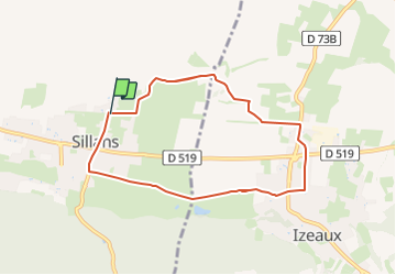
Trail Walking of 8.1 km to be discovered at Auvergne-Rhône-Alpes, Isère, Sillans. This trail is proposed by raymondfn.

Description

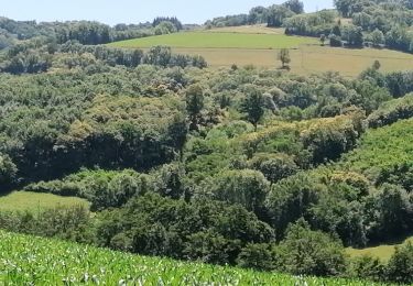
Randonnée plate sans difficulté entre Sillans et Izeaux. Panorama sur les montagnes. Passage le long de la Ravageuse.

Elevation profile

Positioning

Country:
France
Region :
Auvergne-Rhône-Alpes
Department/Province :
Isère
Municipality :
Sillans
Location:
Unknown
Start:(UTM)
687531 ; 5024191 (31T) N.

Comments

Please log in to post a review or rate the element


Trails nearby

Trail Walking Saint-Michel-de-Saint-Geoirs - SaintMichel-Les Arêtes - Photo
Walking
raymondfn

Walking

Medium
(1)
Saint-Michel-de-Saint-Geoirs, Auvergne-Rhône-Alpes, Isère, France
8.9 km | 13.1 km-effort
1h 47min
Yes
Trail Walking Saint-Étienne-de-Saint-Geoirs - st Étienne St geoir - Photo
Walking
goizet

Walking

Easy
Saint-Étienne-de-Saint-Geoirs, Auvergne-Rhône-Alpes, Isère, France
13.2 km | 16.7 km-effort
3h 48min
Yes
Trail Walking Sillans - St Etienne - Photo
Walking
lilloue

Walking

Easy
Sillans, Auvergne-Rhône-Alpes, Isère, France
3.4 km | 3.6 km-effort
48min
No
Trail Walking Sillans - plan - Photo
Walking
Véronique Morel

Walking

Medium
Sillans, Auvergne-Rhône-Alpes, Isère, France
8.6 km | 12 km-effort
2h 51min
No
Trail Walking Sillans - sillans - Photo
Walking
lilloue

Walking

Medium
Sillans, Auvergne-Rhône-Alpes, Isère, France
10.2 km | 11 km-effort
2h 56min
Yes
Trail Walking La Frette - la Frette - Photo
Walking
lilloue

Walking

Easy
La Frette, Auvergne-Rhône-Alpes, Isère, France
5.3 km | 6 km-effort
2h 7min
No
Trail Walking Sillans - Sillans avec Véro - Photo
Walking
lilloue

Walking

Medium
Sillans, Auvergne-Rhône-Alpes, Isère, France
7.4 km | 10.4 km-effort
2h 32min
Yes
Trail Walking Izeaux - Izeaux-le tour des carrières - Photo
Walking
raymondfn

Walking

Easy
Izeaux, Auvergne-Rhône-Alpes, Isère, France
5.4 km | 5.9 km-effort
1h 20min
Yes
Trail Walking Saint-Michel-de-Saint-Geoirs - St Michel de St Geoirs - Photo
Walking
lilloue

Walking

Difficult
Saint-Michel-de-Saint-Geoirs, Auvergne-Rhône-Alpes, Isère, France
10 km | 14.4 km-effort
3h 25min
Yes


Close
My subscriptions