


Citadelle et terrils Myriam

Philippe Moraux
User
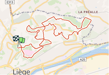

Length
13.4 km

Max alt
190 m

Uphill gradient
346 m
Km-Effort
18 km

Min alt
84 m

Downhill gradient
332 m
Boucle
Yes
Creation date :
2023-11-16 12:26:49.363
Updated on :
2023-11-16 15:35:41.715
3h08
Difficulty : Medium

FREE GPS app for hiking
 SityTrail
IGN / Geographical institutes
SityTrail Plus
The world is yours!
About
Trail Walking of 13.4 km to be discovered at Wallonia, Liège, Liège. This trail is proposed by Philippe Moraux.
Description
belle randonnée qui vous fera découvrir des coins champêtres insoupconnés
Positioning
Country:
Belgium
Region :
Wallonia
Department/Province :
Liège
Municipality :
Liège
Location:
Unknown
Start:(Dec)
Start:(UTM)
681781 ; 5614525 (31U) N.
Comments