


T-Vallée de l'Orge

JLKino
User

Length
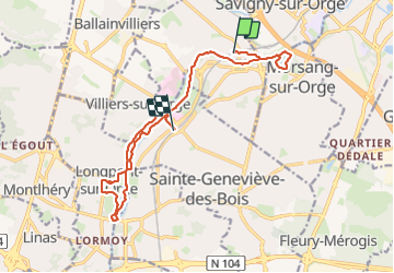
14.8 km

Max alt
65 m

Uphill gradient
127 m
Km-Effort
16.5 km

Min alt
35 m

Downhill gradient
120 m
Boucle
No
Creation date :
2023-11-17 09:12:29.61
Updated on :
2023-11-17 14:30:50.871
5h17
Difficulty : Difficult

FREE GPS app for hiking
 SityTrail
IGN / Geographical institutes
SityTrail Plus
The world is yours!
About
Trail Walking of 14.8 km to be discovered at Ile-de-France, Essonne, Épinay-sur-Orge. This trail is proposed by JLKino.
Photos


Positioning
Country:
France
Region :
Ile-de-France
Department/Province :
Essonne
Municipality :
Épinay-sur-Orge
Location:
Unknown
Start:(Dec)
Start:(UTM)
450761 ; 5390887 (31U) N.
Comments